1. I left the office still connected to the Hub geodatabase, and when I returned in the morning, my connection had been cancelled. Why is this?
Periodic data updates are done to the Hub geodatabase. It is necessary to remove all users's locks prior to updating the geodatabase with the new information. If you are planning on running something that requires a connection all night long, you can contact us. We may be able to postpone our update.
2. I am confused on the definition of township. Sometimes I see or hear township labeled with a name such as "Grand Harbor" and other times with a number such as "159." What is going on?
There are three different ways in which the term "township" is used in geographic and cartographic discussions.
One of the most common references to the term "township" is used in describing the U.S. Public Land Survey System (PLSS). This is the common legal description used in land holdings and refers to a system that was developed in the early 1800’s for describing surveyed land. These townships are also called survey townships or congressional townships (because they were defined by U.S. congressional mandate). This is the system of having a township, 6 miles by 6 miles in size, subdivided into 1 mile by 1 mile sections.
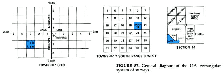
Figure taken from Maps for America, Third Edition, Morris Thompson, USGS, pg. 81, Fig. 87
These townships also have a numbering system that uses the term "township" to indicate the northing row of townships established from an established baseline. Ours (North Dakota’s), is in Arkansas. Using Township 159 North as an example, this indicates that it is the 159th township row that was established north from the baseline in Arkansas. If one takes 159 and multiply by 6 (miles), the result will be 954 miles; and that is about how far north 159 is from the baseline in Arkansas. Range is the term applied to the east/west component of the PLSS township’s "name." As one can see from the example above, Township 2 South, Range 3 West is two townships south of the baseline and 3 townships west of the principal meridian. As an example, Township 159 North, Range 99 West, means it is in the 159th township row north of the baseline in Arkansas and 99 township columns west of the 5th Principal Meridian as shown in the map below.
Figure taken from Maps for America, Third Edition, Morris Thompson, USGS, pgs. 82-83, Fig. 88]
The last use for the term "township" is with civil townships. Civil townships are minor civil divisions with established governments. They can have town boards, town assessors, town clerks, their own maintained roads, etc. They are essentially a governmental sub-division of a county. Many times these townships correspond with PLSS townships. Many times they don’t. There are civil townships in Golden Valley County, North Dakota that cover 4 PLSS townships (i.e., 144 sections). There is one civil township in Ransom County that covers one complete PLSS township, and half (18 sections) of the PLSS township to the south. Most, if not all, of these townships have established names such as the Town of Almond, or the Town of Rose, or the Town of Rome. There are also many areas that are unorganized, meaning that no civil township government structure is in place. There may have been one there at one time, but maybe the residents chose to disband their local government, or maybe the population could no longer support it. Or maybe one was never formed. In either of these cases, the county usually takes over the local governmental issues.
3. How can a township have two sections within its boundaries with the same section number?
As an example, the PLSS surveys of the Sisseton tribal/reservation lands were conducted about the 1869/1870 timeframe, while the surrounding surveys weren't finished until the mid-1880's. A rational explanation is that some mistakes were made due to the surveys being placed in the middle of "no where", 300 miles from the prime meridian and almost 800 miles from the baseline. Normally the PLSS surveys were started in the southeast corner of the township and they would survey each mile north and west until a township was finished. Errors across the township would be corrected when the township was finished by creating government lots on the north and west sides of the township. The townships would be built south to north like a brick building with corrections taking place about every four townships to account for the length of a degree of longitude shortening as you move north (One degree of Longitude at the Equator is about 70 miles while here in ND it is only about 45 miles). So when you consider the time periods and conditions they were working in, and the relatively imprecise methods they were using (compared to now), it's amazing that they came as close as they did. It'd be something like building a skyscraper and putting a window in on the 50th floor and hoping that the wall you built from the ground to the window later would fit exactly. The older surveys hold legal precedence over newer surveys, so nothing would change on the tribal lands even after they discovered the differences.
4. Why is there a number for the HU_12_NAME in the Watershed Boundary Dataset?
Although not very many nationwide, some hydrologic units (HU) carry their number as their name. That is the case for over 300 of the 2,656 hydrologic units in North Dakota. The number is used in places where there is no significant hydrological features or where the hydrologic features are used for larger, parent features, such as near Lake Sakakawea or the Missouri River. We have elected to give many units its number for its name since there is no other water feature that can be used. As the WBD is a certified dataset, this choice was reviewed not only at the state level but the national level as well.
We strive to use GNIS (Geographic Names Information System) names whenever possible, if there is a GNIS feature that falls within the boundaries of a hydrologic unit. In some cases, we could have used a named cemetery or school as a name, but the preferred standard is to use a named hydrographic or geomorphic feature on the landscape (coulee, river, stream, bluff, hill, etc.). If there is no other hydrologic name that would be appropriate for a particular HUC_12 unit, the number is used. It is a common occurrence in North Dakota where there are large areas of un-integrated drainage, unpopulated places, unnamed intermittent creeks, or a large area of a reservoir that spans at least 27 12-digit hydrologic units.
For more information, please contact the North Dakota WBD Data Steward, Ann Fritz at afritz@nd.gov or go to the U.S.G.S. Watershed Boundary website.
5. Where Can I Find Source Water Protection Program Data?
What are the ND_WHPA_Community and ND_WHPA_NonCommunity feature classes?
One of the federally mandated outcomes of the Source Water Protection Program is the delineation of Wellhead Protection Areas (WHPAs) and Source Water Protection Areas (SWPAs); these are areas around a well or surface water intake from which a public water system draws its water. The ND_WHPA_Community and ND_WHPA_NonCommunity layers depict those WHPAs and SWPAs that have been completed by the North Dakota Department of Environmental Quality. The data is dynamic and the GIS layer on the ND GIS hub is updated weekly.
What is the North Dakota Source Water Protection Program?
The North Dakota Source Water Protection Program was developed in response to the 1996 Safe Drinking Water Act amendments that required all states to define and assess the source waters of public water systems. All public water systems that have wells or surface water intakes are participants in the Source Water Protection Program. Three elements of the Source Water Protection Program are federally-mandated requirements and are completed by the Department of Environmental Quality:
- Delineation of the wellhead protection area (WHPA) for groundwater systems or source water protection area (SWPA) for surface water systems,
- Completion of a contaminant source inventory, and
- Completion of a susceptibility analysis.
The remaining four elements (development of management strategies, development of contingency plans, public awareness and procedures when installing new wells) are strictly voluntarily and can be pursued by the governing body of the public water system.
How do I get more information regarding the North Dakota Source Water Protection Program?
For more information on the North Dakota Source Water Protection Program, a list of direct contacts for North Dakota Public Water Systems, or site specific information please visit the North Dakota Source Water Protection website or contact the North Dakota Department of Environmental Quality at 701.328.5210.
6. I'm looking for the NDGIS Blog, where did it go?
As time goes on and technology changes, it's important to periodically take stock on how things are being done and determine if there are more efficient ways of doing those things while maintaining the existing functionality or even improving upon it.
NDGIS Blog
As of November 2022 when we no longer actively used it, the Google-based NDGIS Blog had been serving us well for over 11 years. It appears that the type of content posted on the Blog can now also be done on the NDGIS Website. Although the authoring/editing environment and browsing/searching on the Website aren't as streamlined compared to the Blog, both are functional with the resulting articles containing the same content and usability. In addition, having the content on the Website results in ease of navigation to the content with one or two less clicks. And finally, we've all seen where software providers deprecate certain applications we depend upon. By making the change now, should Google decide to drop their Blogger tool in the future we'll be ready for that.
From this point forward, we will be posting information to the GIS Website news feed, and we plan to no longer post content to the Blog, eventually moving the Blog to archive status with the idea of moving the existing Blog link from the menu on the Website to another location.
If you wish to view the content of the Blog, please visit this link.